
Short Answer
Location
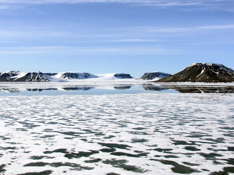
Rudolf Island lies at the extreme northeastern edge of the Franz Josef Land archipelago in the Russian Arctic, positioned at approximately 81°53′ N latitude and 58°57′ E longitude. Its prominent Cape Fligeli marks the northernmost point of the Russian Federation.
Map
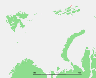
The island sits off the north‑eastern rim of the archipelago, separated from the central group of islands by the Avstriysky (Austrian) Strait. On most modern nautical charts the island appears as a compact, heavily glaciated landmass with Cape Fligeli jutting northward.
Geography
Rudolf Island covers roughly 260 km², of which about 90 % is covered by permanent ice. The terrain is dominated by a central ice cap that rises to the island’s highest point, Mount Rudolf, at 461 m above sea level. The coastal fringe consists of steep, ice‑cliffed shores interspersed with narrow, ice‑free bays that provide limited landing sites for research vessels.
Glaciers
The island’s ice is organized into a few named glaciers that drain the central ice cap toward the sea. The most significant are listed in the table below.
| Glacier | Length (km) | Terminus | Notes |
|---|---|---|---|
| Rudolf Ice Cap | ≈ 12 | Coastal cliffs | Largest ice mass, covers ~90 % of island |
| Cape Fligeli Glacier | ≈ 3 | Cape Fligeli | Flows northward, terminates at the northern tip |
| Northwestern Glacier | ≈ 2.5 | Northwest bay | Small outlet glacier, monitored for melt rates |
Geology
Rudolf Island’s bedrock belongs to the Late Paleozoic sedimentary sequence that characterises much of Franz Josef Land. Predominant lithologies include Devonian‑age sandstones, siltstones, and shales, intruded locally by granitic dykes of Early Cretaceous age. The island’s surface is heavily sculpted by glacial erosion, producing polished rock surfaces and striated outcrops that record past ice flow directions.
Wildlife
Despite its extreme latitude, the island supports a modest Arctic ecosystem. Marine mammals such as ringed seals (Pusa hispida) and bearded seals (Erignathus barbatus) use the surrounding sea ice for pupping. Polar bears (Ursus maritimus) are the apex terrestrial predators, often observed traversing the ice‑covered coast. Avian fauna includes several breeding colonies of the ivory gull (Pagophila eburnea) and Ross’s gull (Rhodostethia rosea), while the sparse vegetative cover consists of mosses, lichens, and dwarf willow (Salix herbacea).
Exploration History
The island was first sighted during the Austro‑Hungarian North Polar Expedition of 1872‑73, led by Julius von Payer and Karl Weyprecht. The expedition named the island after Crown Prince Rudolf of Austria, a patron of the venture. Subsequent Russian Imperial expeditions, notably the 1899‑1902 Russian Arctic Expedition under Baron Eduard von Toll, established temporary scientific camps on the island’s ice‑free bays. During the Soviet era, a seasonal research station operated from the 1930s until the early 1990s, supporting glaciological and meteorological observations.
Historic Sites
Remnants of the 19th‑century Austrian expedition survive as stone foundations near Cape Fligeli, while the abandoned Soviet‑era Rudolf Island Base (“Station Rudolf”) lies on the western coast, its rusted metal structures still visible amid the ice. A commemorative bronze plaque erected in 1973 honours the centenary of the island’s discovery.
Scientific Research
Modern research on Rudolf Island focuses on climate change impacts on Arctic ice. Continuous GPS stations record ice‑cap movement, while automated weather stations (AWS) collect temperature, wind, and precipitation data. International collaborations, including the Arctic Monitoring and Assessment Programme (AMAP), use ice cores drilled from the Rudolf Ice Cap to reconstruct past atmospheric composition and temperature variability over the last 10,000 years.
Name Origin
The name “Rudolf Island” commemorates Crown Prince Rudolf (1858‑1889) of Austria‑Hungary, reflecting the island’s discovery by the Austro‑Hungarian North Polar Expedition. The naming was formalised in Russian cartography during the Imperial era and has been retained in contemporary usage.
Related Islands
Rudolf Island is part of the broader Franz Josef Land group, which includes several large islands such as Zemlya Georgi (2,821 km²), Zemlya Zichy (1,571 km²), and Greem‑Bell Island (1,049 km²). These islands share similar glaciated landscapes, geological histories, and serve as key reference points for Arctic research.
FAQ
What makes Cape Fligeli geographically significant?
Cape Fligeli, on the northern tip of Rudolf Island, is the northernmost point of the Russian Federation, marking the extreme north of the Eurasian continent.
Are there any permanent research stations on Rudolf Island today?
No. The former Soviet‑era Rudolf Island Base was abandoned in the early 1990s; currently only seasonal automated weather and GPS stations operate on the island.
What wildlife can be observed on Rudolf Island?
The island supports polar bears, ringed and bearded seals, breeding colonies of ivory and Ross’s gulls, and sparse tundra vegetation such as mosses, lichens, and dwarf willow.


Leave a Reply