

Short Answer
Location
Wiener Neustadt Island lies in the high Arctic at 80°48′N 58°20′E (80.800° N, 58.333° E). It belongs to the Russian Federation and is situated within the Zichy Land subgroup of the Franz Josef Archipelago.
Map
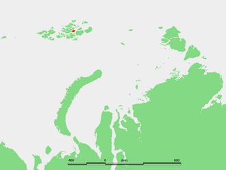 The island is positioned in the eastern sector of Franz Josef Land, separated from Ziegler Island to the west and Salisbury Island to the east by the narrow Collinson Sound. On most modern topographic maps the island appears as a roughly rectangular landmass, heavily shaded to indicate its glacier cover.
Geography
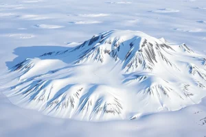
Covering an area of 237 km², Wiener Neustadt Island stretches about 22 km from north‑to‑south and 16 km east‑to‑west. The terrain is dominated by a central ice cap that merges with the surrounding sea‑ice during winter. The island’s most prominent relief is Peak Parnass, rising to 620 m above sea level, the highest point of the entire Franz Josef Land archipelago.
Glaciers
Virtually the whole island is covered by a permanent ice cap. Small outlet glaciers descend from the ice cap toward the coast, feeding into Collinson Sound. Because the ice is continuous, individual glacier names are rarely used, and scientific studies refer to them simply as “the Wiener Neustadt ice cap” and its marginal outflows.
Geology
The bedrock of Wiener Neustadt Island, like much of Zichy Land, consists mainly of Precambrian metamorphic complexes that have been intruded by younger Paleozoic sedimentary layers. These rocks have been modestly studied during Soviet‑era geological surveys, which identified a mix of gneiss, schist, and quartzite, typical of the central Franz Josef Land region.
Wildlife
Terrestrial vegetation is limited to hardy lichens and mosses that grow on exposed nunataks. The surrounding Arctic waters support a seasonal assemblage of marine mammals, including ringed seals, bearded seals, and occasional walrus haul‑outs. Polar bears use the island as a transient hunting platform, while seabirds such as the ivory gull and Arctic tern nest on ice‑free cliffs during the brief summer.
Exploration History
The island was first sighted and named during the Austro‑Hungarian North‑Pole expedition of 1872‑1874, led by Julius Payer and Karl Weyprecht. The explorers christened the island after the Austrian town of Wiener Neustadt, honoring a hometown of several expedition supporters. Subsequent Russian expeditions in the early 20th century mapped the island in greater detail, and Soviet scientific teams established temporary field camps during the 1950s‑1970s.
Historic Sites
No permanent settlements exist on Wiener Neustadt Island. The only archaeological traces are the occasional stone cairns erected by early explorers and the remnants of Soviet‑era research huts, now largely collapsed and buried under snow.
Scientific Research
Since the 1950s, the Russian Academy of Sciences has used the island as a natural laboratory for glaciological and climatological monitoring. Ice‑core samples extracted from the central ice cap have contributed to reconstructions of Holocene temperature variability in the high Arctic. More recent satellite‑based studies monitor the ice‑cap’s mass balance and its response to accelerating Arctic warming.
Name Origin
The name “Wiener Neustadt Island” (Russian: Остров Винер‑Нёйштадт) reflects the practice of the Payer‑Weyprecht expedition to honor Austrian towns and patrons. The island’s Russian name retains the original German spelling, underscoring its historical ties to the Austro‑Hungarian discovery.
Related Islands
Wiener Neustadt Island is part of a cluster of islands that together form the Zichy Land subgroup. Notable neighbours include:
- Ziegler Island – lies to the west across Collinson Sound.
- Salisbury Island – lies to the east, also separated by Collinson Sound.
- Franz Josef Land – the broader archipelago comprising over 190 islands, of which Wiener Neustadt is one of the more elevated.
FAQ
What is the highest point in Franz Josef Land?
Peak Parnass on Wiener Neustadt Island, rising to 620 m above sea level, is the highest summit in the entire Franz Josef Archipelago.
Is Wiener Neustadt Island permanently inhabited?
No. The island has no permanent population; only occasional temporary research camps have been established during scientific expeditions.
How did Wiener Neustadt Island get its name?
It was named by the 1872‑1874 Austro‑Hungarian North‑Pole expedition after the Austrian town of Wiener Neustadt, honoring supporters of the journey.


Leave a Reply