
Short Answer
Location
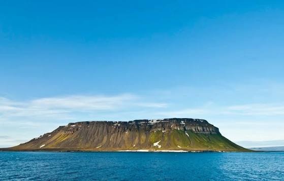
Northbrook Island lies at the southern edge of the Franz Josef Archipelago in the Russian Arctic (79°54′N 50°54′E). It is part of Arkhangelsk Oblast and sits within the high‑latitude polar climate zone.
Map
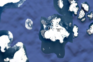
The island is shown on most modern nautical charts of the Arctic as a sizable landmass west of Rudolf Island and east of Zichy Land. Its position makes it one of the most accessible islands in the group, especially during the brief summer ice‑free period.
Geography
Covering roughly 1,050 km², Northbrook Island measures about 22.4 km in length and 19.2 km in width. The terrain is dominated by low‑lying ice‑covered plateaus punctuated by a few ice‑free coastal zones, the most notable being Cape Flora on the southwestern shore (79°57′N 50°05′E). The island’s highest point reaches 344 m above sea level.
Glaciers
The island is heavily glaciated; its interior is covered by a continuous ice cap that feeds several outlet glaciers draining toward the coast. Detailed glacier naming has been limited, but the primary ice flows are identified by their drainage basins.
| Glacier | Location | Approx. Length (km) |
|---|---|---|
| Northbrook Ice Cap Outlet | Central plateau, north‑west flow | ~5 |
| Southwest Coastal Glacier | Approaches Cape Flora | ~3 |
Geology
Northbrook Island rests on Precambrian crystalline basement rock overlain by Pleistocene glacial deposits. The island’s bedrock consists mainly of metamorphic schists and gneisses, typical of the Arctic Cordillera that underlies much of Franz Josef Land. Periglacial processes dominate the surface, creating patterned ground and ice‑wedge polygons.
Wildlife
Although uninhabited by humans, the island supports a modest Arctic fauna. Seasonal walrus haul‑outs are recorded at Cape Flora, and the surrounding waters host ringed seals and occasional narwhals. Polar bears traverse the sea ice and may use the island for denning when snow accumulation is sufficient. Birdlife includes nesting colonies of little auk and murre on the ice‑free cliffs.
Exploration History
Discovered in 1880 by English explorer Benjamin Leigh Smith, the island was named for the Earl of Northbrook, then president of the Royal Geographical Society.1 Smith’s ship was wrecked at Cape Flora in 1881, establishing the site as a wintering ground. In 1896, a chance encounter between Fridtjof Nansen and Frederick George Jackson occurred at Cape Flora, cementing the location’s place in polar lore.1 Subsequent expeditions—such as the American Ziegler Polar Expedition (1904) and the tragic Svyataya Anna voyage (1912‑1914)—used the island as a rescue and supply point.
Historic Sites
Cape Flora retains remnants of 19th‑century encampments, including stone foundations, iron fittings, and a small cairn erected by Leigh Smith’s party. Artefacts from the Ziegler expedition’s coal mine, located about 150 m up the island’s slopes, are still visible. The site is protected as a historic monument by the Russian Ministry of Culture.
Scientific Research
Since the 1980s, Northbrook Island has hosted a series of multidisciplinary studies. Ice‑core drilling on the central ice cap has yielded climate records extending back >100,000 years, informing models of Arctic temperature variability. Biological surveys in the 2000s documented walrus population dynamics and polar‑bear movement patterns via satellite telemetry. Recent remote‑sensing campaigns (e.g., using the icebreaker Yamal in 2006) have refined the island’s coastline and confirmed the existence of a narrow strait separating the western and eastern landmasses.1
Name Origin
The island’s name honors Thomas George Northbrook, 1st Earl of Northbrook, who served as president of the Royal Geographical Society from 1879 to 1880. The naming reflected the customary practice of the era to commemorate patrons of exploration.
Related Islands
Northbrook Island is part of a larger cluster of islands within Franz Josef Land. Adjacent islands include:
- Robertson Island – a small island off the eastern shore of Northbrook, named after Scottish explorer Thomas Robertson.
- West Northbrook Island – the western fragment separated by the strait identified in the 1980s.
- East Northbrook Island – the larger eastern mass containing the island’s interior ice cap.
- Rudolf Island – the northernmost island of the archipelago, historically significant for the Ziegler expedition.
FAQ
Why is Cape Flora historically important?
Cape Flora served as a winter base for several 19th‑century expeditions, including the shipwreck of Benjamin Leigh Smith in 1881 and the famous 1896 meeting of Fridtjof Nansen and Frederick George Jackson.
Are there any permanent research stations on Northbrook Island?
No permanent stations exist; however, seasonal field teams conduct ice‑core drilling, wildlife monitoring, and geological surveys during the brief summer window.
What wildlife can be observed on or near Northbrook Island?
Walrus haul‑outs at Cape Flora, ringed seals in surrounding waters, seasonal polar‑bear visits, and seabird colonies of little auk and murre on the ice‑free cliffs.


Leave a Reply