
Short Answer
Location
Champ Island (Russian: Остров Чамп, Ostrov Champ) lies at 80°40′26″ N, 56°14′13″ E in the Zichy Land subgroup of the Franz Josef Land archipelago, Russia. It is the southernmost island of the Zichy group and is part of the Primorsky district of the Russian Arctic.
Map
The island is separated from Luigi Island to the north and Salisbury Island to the northeast by narrow sounds. To its west the broad Markham Sound (Пролив Маркама) runs between Champ Island and the main body of the archipelago.
Geography
Champ Island covers an area of 374 km² (144 sq mi) and possesses a coastline of roughly 90.6 km (297,244 ft). The terrain is dominated by a central ridge that reaches a maximum elevation of 507 m (1,663 ft) above sea level. The southwest quadrant hosts a relatively extensive unglacierized zone, which contrasts with the island’s predominantly ice‑capped interior.
Glaciers
The island’s ice cover consists of several small outlet glaciers that descend from the central ridge toward the coast. The most notable are:
| Glacier | Approx. Length | Terminus |
|---|---|---|
| North‑East Glacier | ≈2 km | Markham Sound |
| South‑West Glacier | ≈1.5 km | Unglacierized zone |
These glaciers are typical of the high Arctic: thin, cold‑based, and relatively stagnant, responding slowly to climatic fluctuations.
Geology
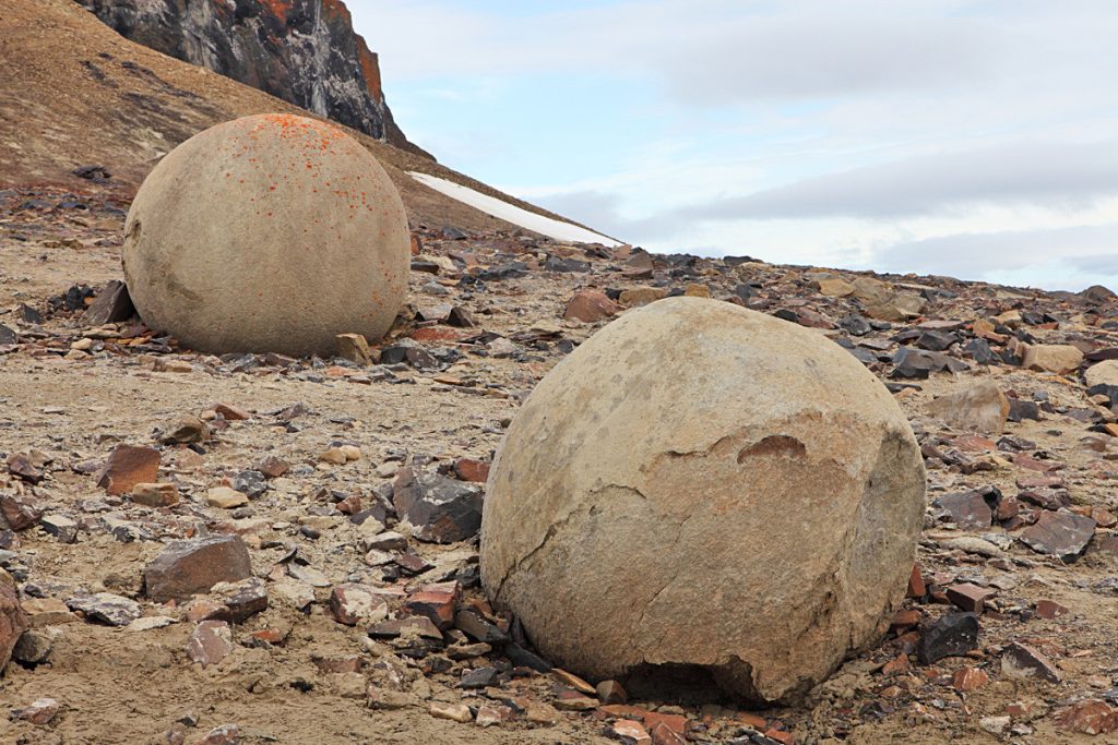
Champ Island is famous for its concretions—large, often spherical stone formations ranging from a few millimetres to several metres in diameter. The spheres are composed primarily of quartzite and sandstone cemented by silica‑rich fluids that precipitated during the late Pleistocene. Their origin is still debated, with prevailing hypotheses invoking diagenetic processes in a periglacial environment.
The bedrock of the island belongs to the late Precambrian to early Paleozoic sedimentary sequence that underlies much of the Franz Josef Land archipelago. Structural studies indicate gentle folding and limited faulting, reflecting the island’s position within the Arctic Alaskan‑Eurasian plate margin.
Wildlife
Despite its harsh climate, Champ Island supports a modest Arctic ecosystem. The unglacierized southwest provides nesting grounds for several seabird species, including the common eider (Somateria mollissima) and the ivory gull (Pagodroma nivea). Marine mammals such as ringed seals (Pusa hispida) frequent the surrounding waters, while polar bears (Ursus maritimus) are occasional visitors, using the ice edge as a hunting platform.
Exploration History
The island was named after William S. Champ, the American representative of the late William Ziegler and leader of the 1903–1905 relief expedition that searched for Anthony Fiala’s party from the Fiala‑Ziegler Polar Expedition. Contemporary newspaper accounts (New York Times, May 1904) recorded Champ’s leadership in navigating the treacherous ice of the archipelago.1
In August 2006, a century‑old ski fragment was recovered at Cape Trieste (Mys Triest) on the island’s eastern coast, providing tangible evidence of early 20th‑century human activity in the region.1
Historic Sites
Key historic locations on Champ Island include:
- Cape Trieste (Mys Triest) – Site where the ski fragment was found.
- Markham Sound – Named after Admiral Sir Albert Hastings Markham, a British polar explorer.
While no permanent structures remain, these sites are documented in early expedition logs and serve as reference points for modern researchers.
Scientific Research
Recent studies have focused on the island’s stone spheres, employing petrographic microscopy, isotopic dating, and ground‑penetrating radar to constrain their formation age. Friedhelm Thiedig’s 2005‑2006 field campaign produced the most comprehensive dataset to date, suggesting a diagenetic origin during the late Pleistocene permafrost expansion.1
Glaciological monitoring of the outlet glaciers contributes to the broader understanding of Arctic ice‑mass balance. Satellite imagery (e.g., Sentinel‑2) and occasional field surveys track seasonal snow cover and glacier terminus positions.
Name Origin
The island’s eponym, William S. Champ (1865–1935), was a seasoned Arctic navigator who coordinated the 1903 rescue effort for the Fiala‑Ziegler expedition. His contributions to polar logistics earned him recognition by the International Polar Committee, which recommended naming the newly charted island in his honour.
Related Islands
Champ Island is part of the Zichy Land subgroup, which includes several notable islands:
- Luigi Island – Lies directly north of Champ Island; largely glaciated.
- Salisbury Island – Situated to the northeast; known for its steep coastal cliffs.
- Ziegler Island – Named after the American philanthropist William Ziegler; hosts a small research outpost.
- Graham Bell Island – The largest island in the archipelago (≈2,560 km²) and site of the Russian research station Nagurskoye.
- Alexandra Land – Westernmost major island; contains the historic Cape Arctic.
Collectively, these islands form the core of Franz Josef Land, an archipelago encompassing roughly 191 islands and a total land area of about 16,134 km².
FAQ
What are the stone spheres found on Champ Island?
The stone spheres are natural concretions composed mainly of quartzite and sandstone cemented by silica‑rich fluids. They range from millimetres to several metres in size and are thought to have formed during the late Pleistocene as diagenetic processes operated within permafrost‑affected sediments.
Can tourists visit Champ Island today?
Champ Island has no permanent facilities and is only reachable by icebreaker or aircraft equipped for Arctic operations. Visits are limited to scientific expeditions or specially chartered tours that obtain permits from the Russian Arctic authority.
How does Champ Island contribute to Arctic climate research?
The island’s small outlet glaciers are monitored for changes in length and mass balance, providing data on regional ice‑mass response to warming. Additionally, the permafrost‑bound concretions offer a proxy for studying past climate conditions in the high Arctic.


Leave a Reply