
Short Answer
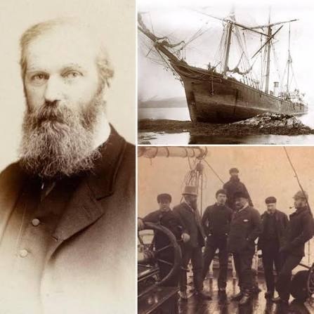
Benjamin Leigh Smith (1828‑1913) was a wealthy English yachtsman and amateur scientist who became one of the most important yet overlooked explorers of the high Arctic. Between 1880 and 1882 he mounted two expeditions to the newly discovered archipelago of Franz Josef Land, then a blank spot on the polar map. Operating from the schooner Eira, he spent the winter of 1880‑81 at Cape Flora on Northbrook Island, conducted extensive sledge surveys, and returned with a trove of scientific observations and a remarkably accurate chart of the islands.
Leigh Smith’s voyages were remarkable for their relative self‑sufficiency, the careful preservation of his field journals, and the large number of islands he named—many of which retain his names today. Although he published little, his records were later disseminated through the Royal Geographical Society and formed the basis of the first reliable maps of Franz Josef Land, predating the more famous Nansen and Jackson expeditions.
Who Was Benjamin Leigh Smith / The Expedition
Born into a wealthy English family in 1828, Leigh Smith inherited a fortune that allowed him to pursue scientific travel without government patronage. A trained geologist and naturalist, he had previously explored Svalbard (1871‑73) and Jan Mayen (1872). For his Franz Josef Land ventures he selected the 66‑foot wooden schooner Eira, refitted for Arctic conditions, and assembled a small crew of experienced seamen, a physician, and a handful of scientists, including geologist William T. Jones and naturalist Henry H. Richardson.
Objectives
The primary aims were geographic and scientific: to determine the extent of the archipelago, to chart its coastlines, to collect geological and biological specimens, and to test the feasibility of wintering in the high Arctic. The expeditions were privately funded by Leigh Smith himself, with the Royal Geographical Society providing an outlet for the results.
Route
Both voyages set sail from Hull, England, in late summer, crossing the Barents Sea via the northern coast of Norway. In July 1880 the Eira entered the eastern reaches of Franz Josef Land, anchoring at the sheltered bay later named Hafen Bay on the western side of Northbrook Island (≈ 80.5° N, 32.5° E). The ship became ice‑bound, forcing the party to establish a winter camp at Cape Flora. During the 1880‑81 winter the crew carried out sledge journeys to the interior of Northbrook and to neighboring islands such as Hall and Graham. The Eira was freed in August 1881 and returned to England in September.
In the second expedition (1881‑82) Leigh Smith returned with additional supplies, again wintering at Cape Flora. This time the sledge parties extended farther north, reaching the northernmost island of Rudolf Island (≈ 81.8° N, 58.8° E) and mapping the northern coast of the archipelago before departing in August 1882.
Timeline
| Date | Event |
|---|---|
| June 1880 | Departure from Hull aboard the schooner Eira |
| July 1880 | First sighting of Franz Josef Land; anchorage at Hafen Bay, Northbrook Island |
| Late July 1880 | Ship trapped in sea ice; establishment of winter camp at Cape Flora |
| Oct 1880 – Apr 1881 | Wintering activities: scientific observations, sledge surveys, collection of specimens |
| August 1881 | Ice break‑up; Eira freed and return to England |
| May 1881 | Second expedition departs Hull with additional provisions |
| July 1881 | Re‑arrival at Cape Flora; renewed wintering |
| Nov 1881 – Mar 1882 | Extended sledge journeys to Rudolf Island and mapping of northern coast |
| August 1882 | Departure from Franz Josef Land; return to England |
The Franz Josef Land Connection
Leigh Smith’s two voyages produced the first systematic chart of the archipelago. He named 30 islands, including Hall, Graham, and the western group of the Zichy islands, many of which retain his names in modern Russian topography (e.g., Ostrov Hall, Ostrov Graham). His maps were incorporated into the Austro‑Hungarian North Pole Expedition’s 1874‑75 charts and later refined by the Jackson–Harmsworth Expedition (1894‑96). Leigh Smith also established a semi‑permanent depot at Cape Flora, which later served as a shelter for Nansen and Johansen in 1895.
Challenges and Hardships
The expeditions faced severe pack‑ice conditions that trapped the Eira for nine months. Supplies were limited; the crew relied on seal hunting and preserved provisions. Scurvy was a constant threat, mitigated by the consumption of fresh seal meat. Extreme polar night at Cape Flora lasted from late November to late January, with temperatures dropping below –30 °C. The isolation also tested morale, but Leigh Smith’s leadership and the crew’s camaraderie prevented mutiny.
Discoveries and Achievements
- Accurate coastal surveys of more than 250 km of shoreline, establishing the archipelago’s overall shape.
- Discovery and naming of several islands and capes, many of which appear on modern Russian charts.
- Geological observations of Jurassic–Cretaceous marine sediments and basaltic outcrops, later confirmed by Soviet fieldwork.
- Biological collections of polar bear, walrus, and avian specimens, enriching the British Museum’s Arctic holdings.
- Production of detailed field notebooks and sketches that were later published by the Royal Geographical Society.
Outcome and Fate
Both expeditions returned safely, and Leigh Smith continued his Arctic pursuits, later supporting the Jackson–Harmsworth Expedition financially. He never published a narrative himself; instead, he sent his journals to scientific societies, where they were edited and released posthumously. Leigh Smith died in 1913, largely unheralded, but his Franz Josef Land work remained a cornerstone for 20th‑century polar research.
Historical Significance
Historians regard Leigh Smith as “the polar explorer of the first rank” (C. Markham) whose meticulous approach set a new standard for private Arctic exploration. His wintering at Cape Flora demonstrated the feasibility of long‑term habitation in the high Arctic, influencing Nansen’s later overwintering strategy. The maps he produced remained the authoritative reference until the Soviet surveys of the 1930s.
Primary Sources
The principal documentary record consists of Leigh Smith’s unpublished journals and logbooks, preserved in the Royal Geographical Society archives, and the post‑humous compilation Shipwreck at Cape Flora: The Expeditions of Benjamin Leigh Smith, England’s Forgotten Arctic Explorer by P. J. Capelotti (2013) which transcribes these materials and provides extensive commentary.
Related Expeditions
Leigh Smith’s work directly preceded the Austro‑Hungarian North Pole Expedition (1872‑74) that first sighted Franz Josef Land, and it set the stage for the Jackson–Harmsworth Expedition (1894‑96) which further explored the interior. His wintering at Cape Flora was later echoed by Fridtjof Nansen and Hjalmar Johansen’s 1895 overwintering, and the site became a logistical hub for later Soviet scientific stations.
FAQ
What was the main purpose of Leigh Smith’s voyages to Franz Josef Land?
The expeditions aimed to map the unknown archipelago, determine its extent, and collect geological, biological, and meteorological data while testing winter survival techniques.
Did Leigh Smith’s ship become trapped in ice?
Yes, the schooner Eira was ice‑bound at Cape Flora in 1880, forcing the crew to spend the winter there before being freed in the following summer.
How did Leigh Smith’s work influence later explorers?
His accurate charts and successful wintering proved the feasibility of long‑term Arctic habitation, influencing Nansen’s 1895 overwintering and providing a base of geographic knowledge for the Jackson–Harmsworth Expedition.

Leave a Reply